Policy Sectors
Use this search tool to navigate through our various programs and policy pages.
Policy Sectors
Information on this page has been reproduced from Government of Canada’s Environment and Natural Resources portal. Please visit canada.ca to see original content.
Assessing the "water-richness" of Canada is a complex process involving many geographic, physical, economic, and social issues. Canada's fresh water can be found in the form of rivers, lakes, groundwater, ice, and snow. Considering that on an average annual basis, Canadian rivers discharge close to 7% of the world's renewable water supply, Canada appears to have a generous water endowment. Aggregate measures, however, can be deceiving.
Some areas in the interior of British Columbia, the southern Prairies, and the high Arctic experience arid or semi-arid climates (less than 35 centimetres of annual precipitation). In these areas, the water supply is further limited because the groundwater tends to be salty and unsuitable for many uses.
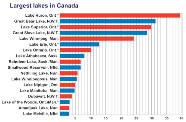
Approximately 60% of Canada's fresh water drains to the north, while 85% of the population lives within 300 kilometres of the Canada-United States border. Many areas have restricted water supplies, and water availability constitutes a major concern for water management. Even in the Great Lakes basin, the world's largest freshwater lake system, some off-lake areas in southern Ontario experience periodic and even chronic water shortage, and groundwater "mining" takes place (i.e., more water is taken out of the aquifer than is being recharged). In this region, a significant increase in the consumptive use or a reduction in the supply of Great Lakes waters would result in a lowering of long-term mean levels of the lakes.
= 31 536 cubic decametres per year (dam3/yr)
= 86 400 cubic metres per day (m3/d)
Fills 2000 backyard swimming pools per day
Fills 1000 rail tank cars per day
In many of the settled areas of the country, water is extremely polluted and is either unsuitable for human, animal, and industrial use or usable only at a relatively high cost of treatment.
Figure - water flow comparisons
Environment Canada's Water Survey of Canada, along with many contributing agencies, presently measures the rate of flow (discharge) in rivers and records the levels of lakes and rivers at more than 2900 locations in Canada.
This table shows typical river flows in meters cubed per second. The annual average, as well as the highest and lowest daily averages are also indicated.
Location |
River |
Annual average |
Daily average |
|
Highest |
Lowest |
|||
Prince Edward Island |
Dunk River at Wall Road |
2.55 |
84.7 |
0.212 |
Saskatchewan |
Qu'Appelle River near Lumsden |
5.44 |
436 |
0 |
New Brunswick |
Lepreau River at Lepreau |
7.37 |
340 |
0.028 |
Manitoba |
Manigotagan River near Manigotagan |
8.93 |
103 |
0.065 |
Ontario |
Rideau River at Ottawa |
37.2 |
583 |
1.48 |
Newfoundland |
Gander River at Big Chute |
119 |
1 170 |
2.78 |
Alberta |
Athabaska River at Hinton |
175 |
1 200 |
10.8 |
Yukon |
Yukon River at Whitehorse |
243 |
646 |
32.6 |
Saskatchewan |
South Saskatchewan River at Saskatoon |
254 |
3 940 |
14.2 |
Quebec |
Rivière aux Outardes à la Centrale de Chute-aux-Outardes |
387 |
2 830 |
10.5 |
New Brunswick |
Saint John River below Mactaquac |
809 |
11 100 |
21.5 |
Ontario |
Ottawa River at Britannia |
1 180 |
5 060 |
245 |
Newfoundland |
Churchill River above Upper Muskrat Falls |
1 740 |
6 820 |
253 |
British Columbia |
Fraser River at Hope |
2 720 |
15 200 |
340 |
Ontario |
Niagara River at Queenston |
5 880 |
9 760 |
2 440 |
Ontario |
St. Lawrence River at Cornwall |
7 350 |
10 700 |
4 500 |
Northwest Territories |
Mackenzie River at Norman Wells |
8 480 |
33 300 |
1 680 |
Note: This table is based on historical data to 1999, extracted from the national HYDAT database.
Water level and discharge information is essential for the wise management of Canada's water resources. For example,
Our rivers and lakes situated north of 60 degrees latitude constitute some of Canada's largest water bodies. The Mackenzie River, for example, is over 4000 kilometres long and is the country's largest river. Great Bear Lake, Northwest Territories, is the world's ninth largest lake (by area). The St. Lawrence-Great Lakes drainage basin is the largest in southern Canada.
Longest rivers in Canada. The illustration shows that the longest rivers in Canada are as follows: Albany River: 980 kilometres; Severn River: 980 kilometres; Assiniboine River: 1070 kilometres; Liard River: 1120 kilometres; Yukon River (Canadian portion): 1150 kilometres; Athabasca River: 1230 kilometres; Ottawa River: 1270 kilometres; North Saskatchewan River: 1290 kilometres; Fraser River: 1370 kilometres; Peace River: 1540 kilometres; Churchill River (Saskatchewan): 1610 kilometres; Nelson River: 2580 kilometres; St. Lawrence River: 3060 kilometres; Mackenzie River: 4240 kilometres.
*Canadian portion only. Note: Numbers have been rounded
Largest lakes in Canada. The illustration shows that the largest lakes in Canada are as follows: Lake Melville, Newfoundland: 3200 square kilometres Amadjuak Lake, Nunavut: 3200 square kilometres Lake of the Woods, Ontario and Manitoba (Canadian portion): 3300 square kilometres Dubawnt, Northwest Territories: 3800 square kilometres Lake Winnipeg, Manitoba: 4800 square kilometres Lake Nipigon, Ontario: 4900 square kilometres Lake Winnipegosis, Manitoba: 5400 square kilometres Nettilling Lake, Nunavut: 5800 square kilometres Smallwood Reservoir, Newfoundland: 6700 square kilometres Reindeer Lake, Saskatchewan and Manitoba: 6800 square kilometres Lake Athabasca, Saskatchewan: 7800 square kilometres Lake Ontario, Ontario (Canadian portion):10 200 square kilometres Lake Erie, Ontario (Canadian portion): 12 800 square kilometres Lake Winnipeg, Manitoba: 24 200 square kilometres Great Slave Lake, Northwest Territories: 28 500 square kilometres Lake Superior, Ontario (Canadian portion): 29 800 square kilometres Great Bear Lake, Northwest Territories: 31 400 square kilometres Lake Huron, Ontario (Canadian portion) : 38 300 square kilometres Note: Numbers have been rounded. The total area includes islands.
*Canadian portion only. Notes: Area in km2 x 1000. Total area including islands. Numbers have been rounded
The Northwest Territories and Nunavut cover 34% of Canada's land mass, and have 18% of its lake area. Average annual runoff produced within the two territories is 18% of the total for Canada, and another 5% of that total flows into this area from the south.
The Northwest Territories' and Nunavut's portion of Canada's fresh water must be estimated on the basis of the total mean annual flow of rivers, as accurate data on water stored in its lakes, under the ground, and in glaciers are unavailable. However, northern runoff is less significant than commonly perceived because the North is a cold desert. Relatively little water is actually circulating in the hydrologic cycle, due to permafrost conditions, seasonal storage of water in snow, and long-term storage in glaciers.
Many Aboriginal peoples of Canada believe that one must consider the impact of any decision on one's children, grandchildren, and great grandchildren seven generations hence to ensure that their needs can be accommodated in the future. Sustainable development has been defined by the Canadian Council of Ministers of the Environment as "development which ensures that the utilization of resources and the environment today does not damage prospects for their use by future generations". For example, industrial development on a river may involve activities that seriously damage our soil, water, and atmospheric systems.
To make the development "sustainable", environmental, social, and economic planning cannot proceed independently of each other. They must be integrated. Our water resources must be developed in harmony with the natural ecosystem so that neither the water resource nor the plant and animal life dependent on it are depleted or destroyed for short-term gain and at the expense of future generations. Long-term economic growth depends on a healthy environment.
Not at all. It is an essential part of the global hydrologic cycle. This water is vital to navigation, recreation, fish and wildlife support, and waste dilution, and so sustains the lifestyles of large and small communities across Canada. Even in the least populated northern reaches of this country, the seasonal fluctuation of high and low flows strengthens a stable relationship among natural forces such as climate, sediment transport, and freshwater discharge to the marine environment. For example, the Mackenzie River system has two inland deltas and one of the world's largest marine deltas, the Mackenzie Delta. (A delta is sediment deposited where a river discharges into a lake or ocean.) Most of the birds using the western flyway make their home in these deltas or use them to rest and feed on their long migrations. Northern rivers flowing into the Arctic Ocean are an essential component of the hydrologic cycle and contribute to this large aquatic ecosystem.
Mackenzie River basin. Map of the Mackenzie River basin showing its major deltas: the Slave River delta at Great Slave Lake in the Northwest Territories; the Peace-Ahtasbasca delta at Lake Athabasca in Alberta; and the Mackenzie delta where the Mackenzie River enters the Beaufort Sea.
Information on this page has been reproduced from Government of Canada’s Environment and Natural Resources portal. Please visit canada.ca to see original content.